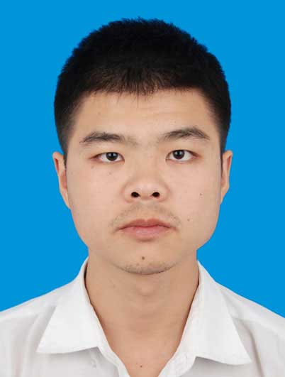
姓名: | 艾金泉 | 性别: | 男 |
|
职称: | 讲师 | 学位: | 博士 | |
单位: | 东华理工大学测绘与空间信息工程学院 | |||
地址/邮编: | 江西省南昌市经开区广兰大道418号/330013 | |||
Email: | jinquan@ecut.edu.cn | |||
研究方向: | 鄱阳湖湿地遥感、遥感云计算 | |||
个人简介
艾金泉,男,1987年生,江西吉安人,博士,硕士生导师。欢迎对鄱阳湖湿地遥感、遥感云计算、GIS开发感兴趣的同学报考硕士研究生。
教育经历
2014年9月—2018年6月,华东师范大学地图学与地理信息系统专业,博士。
2011年9月—2014年6月,福建师范大学地图学与地理信息系统专业,硕士。
2006年9月—2010年6月,福建师范大学地理学国家理科基地专业,学士。
工作经历
2018年7月—至今,东华理工大学测绘与空间信息工程学院,讲师。
科研项目
1.国家自然科学基金地区基金项目(42361059) :不同淹水梯度下鄱阳湖苔草物候遥感反演与应用研究,2024/01—2027/12,主持,在研。
2.东华理工大学博士启动基金(DHBK2018001):时间序列遥感技术支持的鄱阳湖湿地时空动态及其影响机制研究,2018/12—2023/12,主持,在研。
3. 江西省数字国土重点实验室开放基金(DLLJ201917):人类活动引起的鄱阳湖湿地变化遥感诊断研究,2019/09—2020/12,主持,已结题。
4.上海市城市化生态过程与生态恢复重点实验室开放基金(SHUES2019A07):长江河口湿地植被年际变化特征及其驱动机制研究,2019/06—2020/12,主持,已结题。
5. 自然资源部环鄱阳湖区域矿山环境监测与治理重点实验室 2021-2022年度开放基金(MEMI-2021-2022-31):面向深度学习智能提取的环鄱阳湖区域露天矿山样本库构建与应用,2022/12—2024/12,主持,在研。
科研成果
Ai J*, Zhang C, Chen L, Li D. Mapping Annual Land Use and Land Cover Changes in the Yangtze Estuary Region Using an Object-Based Classification Framework and Landsat Time Series Data[J]. Sustainability, 2020, 12:1-18.
Ai J, Gao W, Gao Z*, Shi R*, Zhang C. Phenology-based Spartina alterniflora mapping in coastal wetland of the Yangtze Estuary using time series of GaoFen satellite no. 1 wide field of view imagery [J]. Journal of Applied Remote Sensing, 2017, 11(2):026020.
Ai J, Gao W, Gao Z*, Shi R*, Zhang C, Liu C. Integrating pan-sharpening and classifier ensemble techniques to map an invasive plant (Spartina alterniflora) in an estuarine wetland using Landsat 8 imagery [J]. Journal of Applied Remote Sensing, 2016, 10(2):026001.
Ai J, Gao Z*, Zhang C, Gao W, Shi R, Song D, Chen, M. Estimating reclamation-induced carbon loss in coastal wetlands using time series GF-1 WVF data: a case study in the Yangtze Estuary. Proceedings of SPIE, 2017,10405:108-115.
Ai J*, Niu C, Zhu J, Li H, Chen L. Wetland degradation monitoring using time series of multi-sensor data: A case study of Yangtze River. In 2021 28th International Conference on Geoinformatics, IEEE,2021,1-4.
Du H*, Ai J, Cai Y, Jiang H, Liu P. Combined effects of the surface urban heat island with landscape composition and configuration based on remote sensing: A case study of Shanghai, China[J]. Sustainability, 2019,10:1-13.
Li X, Li Y*, Ai J, Shu Z, Xia J, Xia Y. Semantic segmentation of UAV remote sensing images based on edge feature fusing and multi-level upsampling integrated with Deeplabv3+[J]. PloS one,2023,18(1), e0279097.
Song D, Gao Z*, Zhang H, Xu F, Zheng X, Ai J, Hu X, Huang G, Zhang, H. GIS-based health assessment of the marine ecosystem in Laizhou Bay, China. Marine Pollution Bulletin, 2017,125(1-2), 242-249.
Xu F, Gao Z*, Jiang X, Shang W, Ning J, Song D, Ai J. A UAV and S2A data-based estimation of the initial biomass of green algae in the South Yellow Sea[J]. Marine Pollution Bulletin, 2018, 128(3):408-414.
艾金泉.基于时间序列多源遥感数据的长江河口湿地生态系统长期演变过程与机制研究[J].测绘学报,2020,48(11):1489.
艾金泉, 陈文惠*, 陈丽娟, 张永贺, 周毅军, 郭啸川, 褚武道. 冠层水平互花米草叶片光合色素含量的高光谱遥感估算模型[J]. 生态学报, 2015, 35(4):1175-1186.
韩新星,艾金泉*,叶子君,牛春妹,唐鑫涛.基于遥感云计算的鄱阳湖湿地植被群落分类研究[J].人民长江,2023,54(7):55-60.
牛春妹,艾金泉*,刘浩,朱江涛;韩新星.持续高水位对鄱阳湖自然湿地景观的影响[J].北京测绘,2023,37(5):725-730.
朱江涛,艾金泉*,陈晓勇,牛春妹,肖少龙.基于GEE的鄱阳湖湿地植被长期变化特征及其对水文情势的响应[J].测绘通报,2022(8):7-13.
朱江涛,艾金泉*,陈晓勇,汤宇豪.基于多源光学遥感数据的湖泊湿地分类结果一致性分析[J].地理与地理信息科学,2021,37(4):45-50.
艾金泉,陈文惠*,罗丽娟,章文龙.入侵种互花米草的光谱分层分析方法[J].测绘科学,2015,40(10):118-122.
学生培养
朱江涛,2022年毕业,毕业后在江西省智慧交通运输事务中心工作
牛春妹,2023年毕业,毕业后在宁波市阿拉图数字科技有限公司工作
